33% off
Product Description
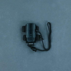
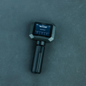
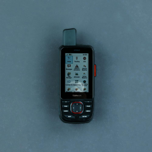
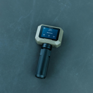
STRONG CONNECTION. STRONG BOND. Track and train your dogs with the Alpha 200i system, featuring inReachA(R) technology1, a sunlight-readable 3.5" capacitive touchscreen and user-friendly, six-button design2. Easily pair the handheld to select T and TT(TM) series collars. Alpha 200i Handheld Comes With: AlphaA(R) 200i handheld with rechargeable lithium-ion battery pack Belt clip AC adapter microUSB cable Documentation TRACK YOUR PACK Monitor up to 20 dogs with your compatible dog collars from up to 9 miles with a 2.5-second update rate. DOG LIST/GROUP MANAGEMENT Keep inactive dogs in your dog list, and manage active groups so you don&&';;t have to add and remove dogs for every hunt. Pair with your TT(TM) 15 tracking and training collars. PUBLIC LAND BOUNDARIES Optional display of public land boundaries on topographical maps helps you know that you&&';;re venturing where you&&';;re supposed to be. HUNT METRICS See each dog&&';;s daily hunting patterns, distance and speed so you can monitor performance and help prevent overheating. Pair with your compatible Garmin dog collar (sold separately). SIX-BUTTON DESIGN Use dedicated buttons for fast training cues and minor adjustments in the field. 18 LEVELS OF STIMULATION Momentary and continuous stimulation options let you customize training for each dog when used with a compatible training enabled collar. TONE/VIBRATION Issue different levels of audible tone or vibration commands for quick adjustments to individual dogs when used with a compatible training enabled collar. GARMIN EXPLORE(TM) APP Pair with the Garmin Explore app on your compatible smartphone to see real-time dog tracking information, save collections of dog tracks and replay tracks to see exactly what happened during your hunt. OPTIONAL INREACH WEATHER Use inReach connectivity1 to get detailed weather updates on Alpha 200i or your compatible device paired with the Garmin Explore app. Request weather forecasts for your current location, waypoints or destinations on your route. PRO VIEW COMPASS The pro view compass mode gives you simple, at-a-glance tracking that shows which direction and how far away your dogs are, plus you will see when a dog is "Treed" or "OnPoint." MULTI-GNSS SUPPORT Access multiple global navigation satellite systems (GPS and Galileo) to track your pack with greater accuracy than GPS alone. TOPOACTIVE MAPS Our preloaded TopoActive mapping provides detailed views of terrain contours, topographic elevations, summits, parks, coastlines, rivers, lakes and geographical points. BIRDSEYE SATELLITE IMAGERY Download BirdsEye Satellite Imagery directly to the handheld via Wi-FiA(R) connectivity for better-than-real-life views of your route, trailheads, clearings and more. NAVIGATION SENSORS A barometric altimeter helps you accurately monitor ascent and descent and see short-term trends in air pressure, and the built-in tilt-compensated 3-axis electronic compass keeps your bearing - whether you&&';;re moving or not. SEE IT ALL The sunlight-readable 3.5" capacitive touchscreen display makes it easy to see and interact with your maps, dog data and more - even while wearing gloves. STAY ON THE MOVE Replaceable battery lasts up to 20 hours, or up to 15 hours with inReach technology enabled. ADDITIONAL MAPPING The microSD(TM) card slot allows you to load more mapping options, such as TOPO U.S. 24K and HuntView Plus maps (each sold separately). IN-VEHICLE TRACKING If you&&';;re using a vehicle to follow and retrieve your dogs, the rugged TreadA(R) off-road powersport navigator, the Garmin DriveTrack(TM) 71 car navigator or a MontanaA(R) 700 Series handheld (each sold separately) provide an easy-to-watch "big picture" solution. The moving map display shows dog positions overlaid on TOPO contours or satellite image views - along with navigation cues that help point you to your dog&&';;s current location. TWO-WAY MESSAGING Exchange text messages with loved ones, post to social media, or communicate inReach to inReach in the field (active satellite subscription required)1. INTERACTIVE SOS ALERTS In case of emergency, trigger an interactive SOS message to the Garmin IERCC, a 24/7 staffed professional emergency response coordination center (active satellite subscription required). LOCATION SHARING Track your location, and share it with those at home or out in the field so they can see your progress or ping your device for your GPS location and more (active satellite subscription required)1. 100% GLOBAL IRIDIUMA(R) SATELLITE NETWORK Instead of relying on cellphone coverage, now your messages, SOS alerts and tracking are transferred via the global Iridium satellite network (active satellite subscription required)1. 1Active satellite subscription required. Some jurisdictions regulate or prohibit the use of satellite communications devices. It is the responsibility of the user to know and follow all applicable laws in the jurisdictions where the device is intended to be used. 2Requires compatible dog collars (sold separately) Engineering enhancements are ongoing and may not be reflected in the pictures, videos and specifications. General Dimension 2.7 x 6.4 x 1.3" (6.8 x 16.2 x 3.4 cm) *dimensions do not include antenna Weight 9.9 oz (280 g) with standard antenna and battery Water rating IPX7 Touchscreen yes Display Type transflective, color TFT touchscreen Display Size 1.8" W x 3.0" H (4.7 x 7.7 cm); 3.5" diag (88.9 mm) Display resolution 282 x 470 pixels Battery Type rechargeable lithium-ion (included) Battery life up to 20 hours; up to 15 hours with inReachA(R) technology enabled Memory/History 16 GB Interface high-speed USB Maps & Memory Preloaded maps yes (TopoActive) Ability to add maps yes Basemap yes Automatic routing (turn by turn routing on roads) for outdoor activities Yes (with optional mapping for detailed roads) Satellite Imagery yes, direct to device (no annual subscription required) External memory storage microSD(TM) card (not included) Waypoints/favorites/locations 10,000 Tracks Up to 20 assets (any combination of compatible dog devices and handhelds) Navigation Track Log 20,000 points, 250 saved gpx tracks, 300 saved fit activities Navigation Routes 250 Stored contacts 250 dogs Group management yes Sensors GPS yes Galileo yes Barometric altimeter yes Compass Yes (tilt-compensated 3-axis) High-sensitivity receiver yes Daily Smart Features Compatible with Garmin Messenger app yes Safety and Tracking Features LiveTrack yes Tactical Features XERO(TM) Locations yes Outdoor Recreation Point-to-point navigation yes Area calculation yes Fish forecast yes Sun and moon information yes Custom maps compatible yes inReachA(R) Features Interactive SOS yes Send and receive text messages to SMS and email yes Send and receive text messages to other inReach device yes Exchange locations with other inReach device yes Virtual keyboard for custom messaging yes Send waypoints to MapShare during trip yes Send route selection to MapShare during trip yes Radio Features Frequency band MURS Channels 5 Range 9 miles with compatible dog devices Location reporting (send and receive GPS positions) yes Vibration alert yes Contacts yes Outdoor Applications Compatible with Garmin Explore(TM) app yes Garmin Explore website compatible yes Dog tracking yes Connections Wireless Connectivity yes (Wi-FiA(R), BLUETOOTHA(R) and ANT+A(R))

Garmin Alpha 200i Dog Tracking/Training Handheld w/ inReach Technology
$499.99
$749.99
33% Discount
You save $250.00
In Stock
at MojoMotoSport.com
 Amazon
 eBay
eBay
Product Details
Brand
Garmin