Product Description
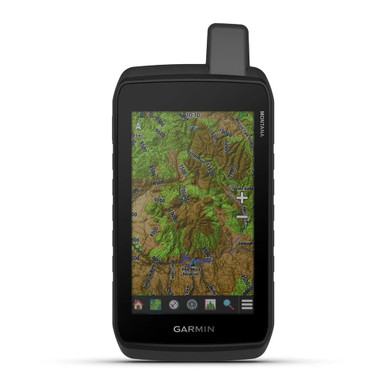
Whether you’re hiking the backwoods or out on the water, the Montana 680t GPS allows you to navigate with confidence. It utilizes high-sensitivity GPS and GLONASS reception for greater navigational accuracy than GPS alone, and features a WAAS-enabled receiver and HotFix satellite prediction for quickly and precisely locating your position even in challenging environments like deep woods or near tall buildings. The Montana 680t comes preloaded with TOPO U. S. 100K maps which can be upgraded by downloading TOPO U. S. 24K maps, and comes with a 1-year subscription to BirdsEye Satellite Imagery for photo realistic images. This handheld navigator can also be optimized for city driving by loading City Navigator for turn-by-turn driving directions, and plugging in BlueChart g2 preloaded cards enables maritime navigation. Other features of the Montana 680t include an integrated 8-megapixle digital camera which automatically geotags your photo with coordinates so you can find your way back to the exact sport where the picture was taken, and a built in 3-axis tilt-compensated digital compass will keep you pointed in the right direction even if you’re not holding it level. Features of the Montana 680t GPS: GPS and GLONASS reception for greater navigational accuracy than GPS alonePreloaded with TOPO U. S. 100K maps1-year subscription to BirdsEye Satellite ImageryIntegrated 8-megapixle digital camera which automatically geotags your photo with coordinates3-axis tilt-compensated digital compassBuilt-in barometric altimeter Garmin Montana 680t US TOPO 100k Handheld GPS 010-01534-11